GAGAN system
GAGAN system : A joint project by ISRO and AAI

GAGAN is stands for GPS Aided GEO Augmented Navigation . It is a regional Satellite Based Augmentation System (SBAS) implemented by government of India.The project was launched in 2001 but gets fully operational in 2013,14 . 30 dec. 2012 , the Directorate General of Civil Aviation (DGCA) India certified the GAGAN to RNPo.1(Required Navigation Performance, o.1 nautical miles or 0.19 km).
It helps in safe and successful landing of aeroplane and aircrafts managing the lands and mines , train and ships navigation. It also helps in Agriculture, Defence, and dragster management.
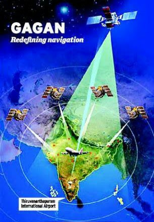
There are two types of navigation system I.e Global Positioning System and Regional Navigation System. GAGAN is a Regional Navigation System. It is developed jointly by Indian Space and Research Organization ISRO and Airport Authority of India AAI. It developed to provide better navigational service for Indian Aviation, with also forest management, scientific research, natural resources and land management, railways signaling. It is a system of satellites and ground stations.
GAGAN works with set of ground stations at various locations in India called Indian Reference Station (INRES) , it collect Satellite data. In Bangalore, Indian Master Control Center (INMCC) a master station , it collects data from reference stations and creates GPS correction message. These messages are uplinked with Indian Uplink Station (INLUS) and broadcasted on a signal from three geostationary satellites I.e GSAT-8, GSAT-10 ,GSAT-15 .
GAGAN covers a wide range from Africa to Australia but serves only in Asia .
Before GAGAN, this technology was only in two countries America and Europe. India is third for this technology, now Europe also having it.Wide Area Augmentation System (WAAS) is American, European Geostationary Navigation Overlay Service (EGNOS) is European and MTSAT Satellite Augmentation System (MSAS) is Japanese.
Under this project 15 Indian reference stations are made , 3 Indian Navigation land uplink stations, 3 Indian mission control centers are also made.. The accuracy of navigation by pilots will be 3m or 9.8ft in Indian Airspace.
GAGAN provides 3D approach operation with course guidance to the runway. It will increase safety and reduce the risk of controlled flight into different terrain.
.png)
.jpeg)

.png)

.png)
.png)
.png)
.png)
Comments
Post a Comment